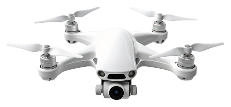

Our digital products and services help farmers and industries improve their productivity and sustainability by providing them with data and insights into their crops and land.
We provide a precision agriculture platform that acquires site-specific information (for example, visual observation of crop and soil differences using UAVs ) and blends it with a mix of farmer intuition , scientific analysis of data and AI for maximising yield.
We offer a “Tech Soft” approach to Farmers to adopt our solutions at their own pace and convenience.
Smart agro digital products & solutions for sustainable future
This plug-and-play system harnesses the power of Al-driven multispectral drone imaging to proficiently identify early indicators of crop growth, disease, nutritional performance, and climate patterns.
Drone Assisted Precision Agriculture Application Console

Greenario AgroEye
This proactive approach empowers farmers to implement corrective measures in a timely manner, preventing issues from escalating, thereby optimizing cost-efficiency and enhancing overall yields.
Identify early indicators of
-
crop growth disease
-
nutritional performance
-
climate patterns.


Why choose Greenario AgroEye

AgroEye delivers an instantaneous field snapshot, significantly reducing the time required for manual scouting.
With the capacity to cover vast expanses of land, spanning hundreds of hectares in a single flight, it captures critical data essential for detecting and identifying variability as well as areas experiencing crop stress.
Effective coverage

AgroEye facilitates the generation of prescription maps and plans, enabling a more targeted and efficient approach to treatments, ultimately reducing costs. These insights seamlessly integrate with other agronomic tools, providing a comprehensive understanding of the agricultural landscape. Additionally, the drone data serves as a valuable guide, directing users to optimal sampling locations, resulting in time and cost savings
Accurate analysis

The periodic capture of calibrated data from professional multispectral sensors provides consistent insights into crop health, unaffected by changes in illumination. This ensures a reliable source of data to derive quantitative trends, offering a comprehensive understanding of crop conditions over time
Data Management

-
Monitor Acres of crops daily
-
Crop growth Analysis
-
Monitor Pesticide performance
-
Al Based Crop Counting
-
Remote sensing
-
Ground sensing
Features

-
UAV built-in flight planning for automated crop monitoring
-
Integrated image processing functionalities for orthomosaic extraction and vegetation health estimation (Vegetation-Indices module)
-
Automatically extracts possible problematic areas of the field (Problematic-Areas-Detection module) and subsequently designs a follow-up UAV mission to acquire extra information on these regions
-
UAV built-in site-specific mission based on the extracted knowledge and combined with incorporated deep learning model (Weed-Detection module) trained on the Greenario-WeedDB dataset for weed detection
-
Timeline view for storing information according to the year's harvest
AgroEye
Specifications


How it works?

AgroEye-1 is a precision agriculture platform thatuses Al-powered multispectral drone imaging to detect crop disease and nutrition early on. This allows you to take corrective action before problems escalate, saving them money and improving their yields.
Step 1

AgroEye-1 works by collecting high-resolution data of crops using a multispectral drone camera.
The camera captures images in multiple wavelengths of light, which allows us to identify crop diseases and nutrient deficiencies that would be invisible to the naked eye.
Step 2

The images are then processed using our Al-powered data mapping systems to generate detailed maps of the crop health. These maps are delivered to farmers through our mobile app, where they can view them in real time and make informed decisions about their crops.
Step 3

